Category Archives: Si

Comment period opens for Teneriffe trailhead

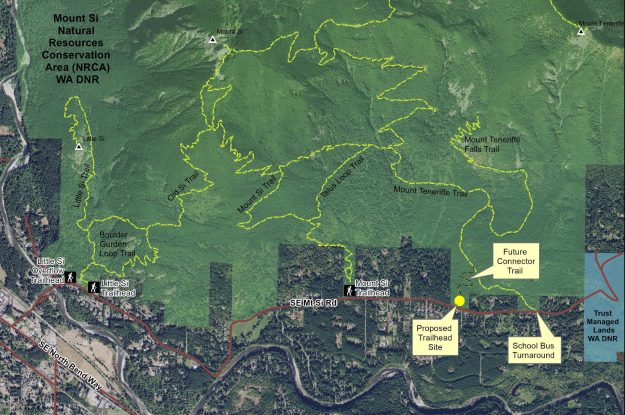
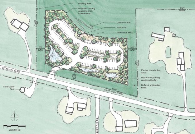
The DNR has released detailed project materials for a proposed new Teneriffe trailhead along the Mount Si road. The SEPA documents are available on the project’s web page and comments should be submitted by Sunday, July 24, 2016. The planed site is not at the school bus turn-around, but at a location closer to the Mount Si trailhead. The plan is very similar to the one discussed at the public forum in January, 2016

Update: In mid-August the DNR released the Notice of Final Determination for the Teneriffe parking lot project. Comments were generally positive but with concerns similar to those that came up in the public forums.

20160628ProposedTeneriffeParkingMap

Proposed Mount Teneriffe Trailhead location


20160628ProposedTeneriffeParkingPlan

Proposed Mount Teneriffe Trailhead – Site Plan (Draft for planning purposes only)

DNR hosts Teneriffe trailhead forum

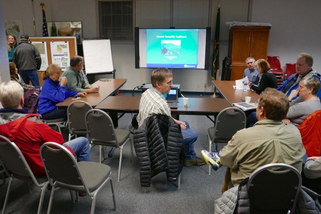
On January 26, 2016 the local DNR staff hosted a neighborhood forum to discuss early stage plans for a new trailhead at the base of Mount Teneriffe. The DNR had previously met with selected neighbors and scheduled a previous forum that was lightly attended because a strong windstorm hit the area that day. This event drew about 40 people, the higher attendance probably due to an article about the meeting in a local newspaper.
20160126TeneriffeTrailheadPlans01

Neighbors filter in as the DNR staff prepares to start the meeting

After a brief overview, Doug McClelland of the local DNR office fielded questions and concerns from the audience for over an hour and half. Doug emphasized that the DNR is not trying to draw more recreation related traffic up the narrow SE Mount Si Road, rather it is trying to solve a problem of inadequate parking at the school bus turn-around as the Mount Teneriffe trails become more popular. This Mount Si NRCA project is only one part of a comprehensive Snoqualmie Corridor Recreation Plan including DNR lands on Tiger Mountain, the Raging River valley, Rattlesnake Mountain, and the Middle Fork Snoqualmie NRCA. Most of the trailheads being developed are close to I-90 and do not involve hikers walking or driving through a residential area. That makes this trailhead particularly sensitive and neighbors from the affected area were not shy to voice their concerns.

Issues

  • Parking and traffic on SE Mt Si Road and in nearby neighborhoods. A few spots along the road are legal to park on, but parking in areas where it’s prohibited only incurs a $20 ticket which most felt is not enough of a deterrent.
  • Safety concerns due to hikers walking along the road when the Mt Si parking lot is full. There are no sidewalks and the shoulder is narrow so the hikers often walk in the traffic lanes
  • Increased traffic on a service level 4 road that receives only minimal maintenance. Most of these issues must ultimately be addressed by King County, but integrated planning by all parties and a coordinated request will probably yield the best results.
  • Concerns about visitors trespassing on private property and inappropriate behavior. One resident found visitors having a picnic on her lawn. Some hikers feel free to change clothes in the middle of the street. Ungated parking lots invite activities unrelated to hiking, including some users frequently staying overnight.
  • Concerns about levels of police patrols and enforcement. This is another issue that extends well beyond the DNR, but should be addressed as part of the plan.
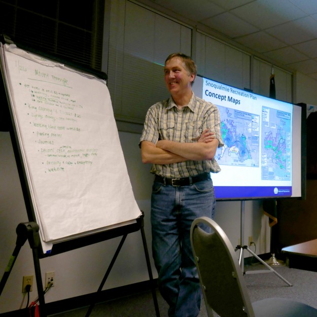
20160126TeneriffeTrailheadPlans04

Doug McClelland fields neighbors questions and concerns


Mitigations

These problems are not going to be easy to solve, but Doug emphasized that there is good cooperation between the various levels of government and other groups funding the projects. Visitation levels have been increasing for years and doing nothing is not a solution. Some of the possible mitigations discussed were

  • Installing a vending machine for purchase a Discover Pass to reduce pressure to park outside the designated areas
  • Continuing the experiment with a shuttle service started in the summer of 2015. It got a lot of publicity but very little use. Ultimately a shuttle service will be needed for both the Mount Si and Middle Fork areas because there will not be enough parking for the anticipated demand. The Middle Fork paving project actually reduces the number of possible parking places because the road is being raised to improve drainage and this results in steep shoulders.
  • Avoid building new trails beyond those that currently exist in the Mount Si NRCA and encourage use of trails in other nearby areas with better access.
  • Consider electronic surveillance to help safety and law enforcement. Automatically monitoring how full the lots are and making the information available online could direct hikers to less busy areas.
  • Improve signage for parking, pass requirements and purchase, and other nearby hiking options

20160126TeneriffeTrailheadPlans05

Attendees got a chance to visit with the local DNR staff after the meeting


Concept Plans

Work on the Teneriffe trailhead and other Snoqualmie Corridor facilities is being funded by a $100,000 grant – RCO 14-1841 Snoqualmie Corridor Facilities Design. The initial thinking when applying for the grant was to build a new parking lot uphill from the school bus turn around where hikers currently park.
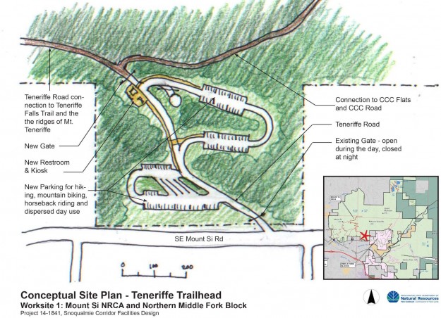
2014TeneriffeTrailheadConcept

An early trailhead concept from the grant application showed a multi-loop parking lot uphill from the school bus turn around, near the water tower.

Work done as part of the grant evaluated the possible trailhead locations more carefully and the preferred site shifted to area B shown below. The DNR staff stressed that these are still concept drawings. Actual plans require significantly more study to evaluate wildlife, drainage, traffic and other impacts.
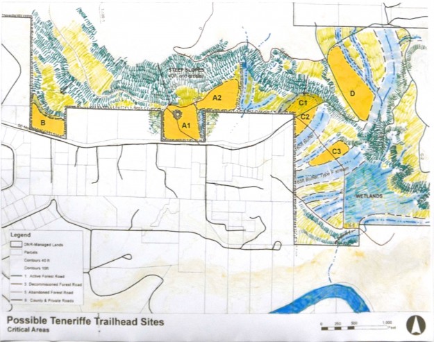
20160126TeneriffeTrailheadPlans03

Locations evaluated for a new trailhead. Relatively flat ground and distance from streams and wetlands are advantageous which made the C and D sites unworkable.
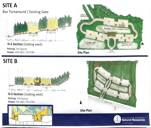
20160126TeneriffeTrailheadPlans02

A comparison of the two most likely sites. Site A was initially favored but turned out to have steeper slopes and more difficult drainage problems than site B, the current front runner.

Related news

01/11/2016 Living Snoqualmie – New Hiking Trailhead, 70 Car Parking Lot Planned for Mt. Si Road, Residents Voice Concerns
Ski descent from Mount Si haystack

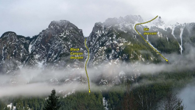
The end of 2015 saw two notable ski feats on Mount Si; one a descent from the top of haystack and the other down the Black Canyon. Both were made possible by unusually heavy snow fall that was stable enough to ski on without triggering slides.

Mount Si from Rachor Place NE

Mount Si from Rachor Place NE


Peter Avolio, Trevor Kostanich and Dave Jordan accomplished a rare ski descent of Mount Si starting from the top of the haystack. Previous descents have been done down the open gullies of the west face. However, this is probably not the first ski descent from the top because other skiers report that it was done in the early 2000s and earlier.

Dave Jordan skis from the top of the Haystack on the summit of Mount Si. Trevor Kostanich is visible to the right of Jordan. Photo by Emily Larson


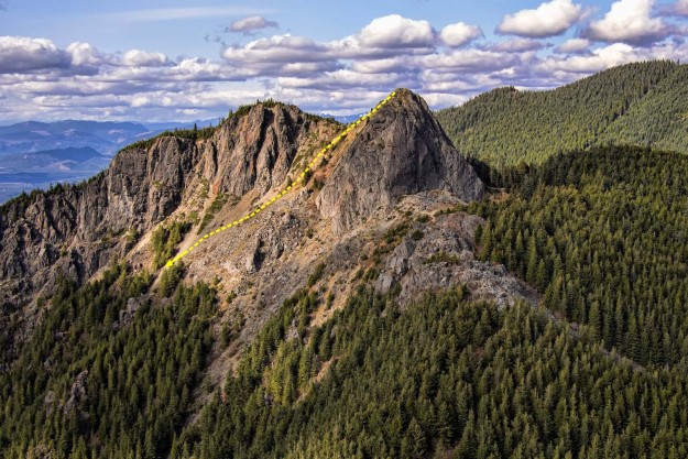
20150422HaystackFromHangGlider

The Mount Si haystack as seen from a paraglider with the skier’s approximate route shown. Photo by Aaron Hinkley.


Trevor Kostanich (left) and Dave Jordan prepare to ski from the top of Mount Si’s summit block. Photo by Peter Avolio.


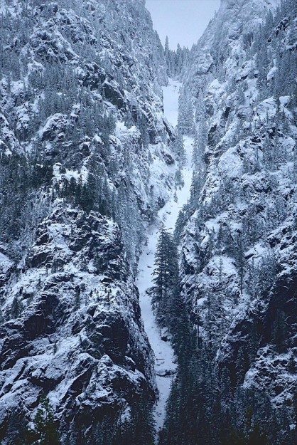
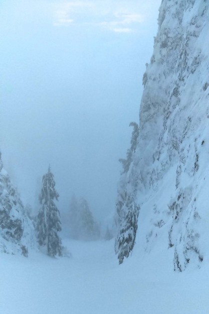
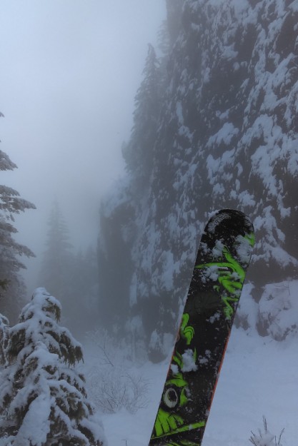
A few days earlier Frank Bush also took advantage of the unusual snow conditions and reported skiing down the Black Canyon. In his words “On Christmas morning Mt Si was ripe, but couldn’t find a partner so I solo skied the deep walled canyon with a 12 foot rock step 2/3 down. Side step down steep rock slab with shrubs to grab (60′) to get into it, then several hundred feet of good pow turns before jump turns on 10″ covered rocks. Rock step near bottom is very obvious, it crosses the whole line from wall to wall.

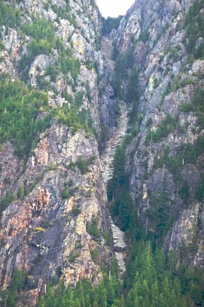
20100214BlackCanyon

The Black Canyon in February, 2010. A difficult scramble route.

20151224BlackCanyon

The Black Canyon in December, 2015. An even more difficult ski line. Photo by Frank Bush.


20151224BlackCanyonSki1

Black Canyon ski descent. Photo by Frank Bush.

20151224BlackCanyonSki2

Black Canyon ski descent. Photo by Frank Bush.


Related News

Mount Si 444 fire

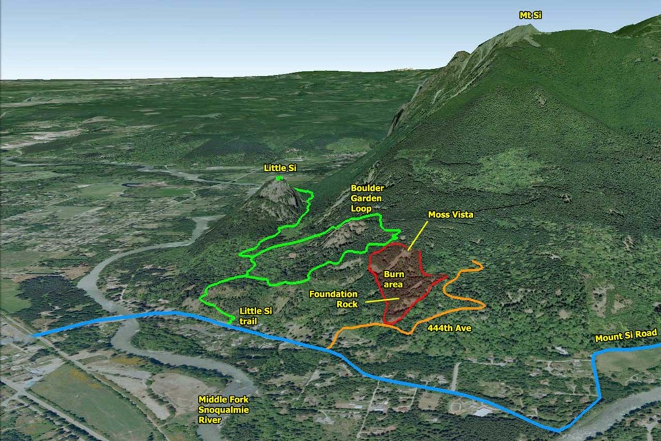
At about noon on July 26, 2013 a fire broke out on the lower elevations of Mount Si along 444th Ave SE. It was probably human-caused, and was named after after the road. Fire fighters had the advantage of using both the Boulder Garden loop and 444th Ave SE to get equipment in the fire area to control the blaze. The fire enveloped three prominent balds visible from the valley – Foundation Rock, BCD Vista and Moss Vista. The first two are rarely visited, but Moss Vista is the largest of the three and has a high overhanging wall with difficult rock climbing routes. The top of Moss Vista is also a popular Boulder Garden Loop side trip for picnics and views, at least for those who know it is there. It is marked on the Green Trails map but there are no signs along the maintained trails showing how to get to it. For the most part the fire burnt the understory and spared the crowns of most trees, so recovery should be relatively rapid.

20130726SiBurn01

Google Earth view showing extent of the burn area


Related coverage

  • 2013/07/26 Wildfire breaks out on Mount Si
  • 2013/07/26 Crews continue to fight wildfire on Mount Si
  • 2013/07/26 Firefighters battling wildfire on Mt. Si near North Bend
  • 2013/07/26 Wildfire burning at Mount Si as King County issues burn ban
  • 2013/07/29 Mount Si wildfire is three-fourths contained, human-caused
  • 2013/07/29 Recreation Update: Mount Si & Little Si open
  • 2013/07/26 DNR, EFR, prison crews attack Mount Si’s ‘444 Fire’
  • 2013/07/31 Wild fire to smolder for several days
  • 2013/08/06 Garden Loop Trail closed indefinitely, fire fully contained, being patrolled
  • 2013/11/06 Forest rebounds after fire

Wing suit jumper missing

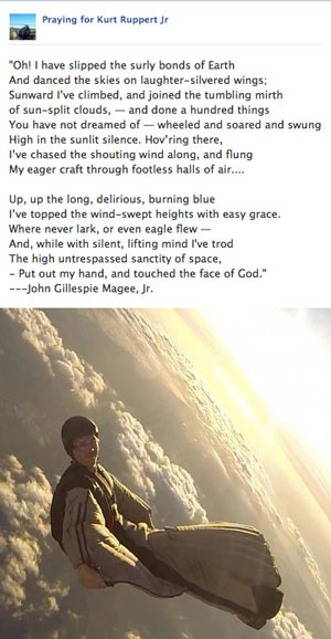
On January 3, 2013 Kurt Ruppert, a Florida wing suit enthusiast, jumped out of a chartered helicopter hovering over Mt Si at 6500′ to begin another of his over 1000 thrilling jumps. It was the last time anyone ever saw him. Two companions jumped just before him and were waiting in the landing zone, but did not see him jump, or see his chute deploy. The Mount Si trailheads were closed to function as a base for Search and Rescue operations. About 145 searchers covered a 9 square mile area on the flanks and cliffs of Mount Si for 4 days before concluding that it was unlikely Kurt had survived, given the cold conditions and lack of contact from him. The story drew national coverage because of the sensational nature of the sport and the suspense over whether Kurt had survived. Messages of grief and condolence convey the tragedy of this accident.
Kurt Rupport Jr

Kurt Ruppert Jr


SMR Mt Si search

Mt Si search below west side cliffs – photo by SMR

SMR Mt Si search

Mt Si search – photo by SMR

SMR Mt Si search

Mt Si search, behind the haystack – photo by SMR


Related coverage

  • 2013/01/04 Searchers comb Mount Si for missing skydiver
  • 2013/01/04 Missing Skydiver Identified
  • 2013/01/04 Missing skydiver had made more than 1,000 jumps
  • 2013/01/05 Crews Continue To Look For Skydiver In Washington
  • 2013/01/04 Search for missing Lake City skydiver resumes Saturday
  • 2013/01/05 Crews narrow search area for skydiver in Wash
  • 2013/01/06 Search Suspended: Skydiver Kurt Ruppert Still Missing on Mt. Si
  • 2013/01/06 Ground search ends for skydiver missing in Washington
  • 2013/01/07 Rescuers scour Washington’s Cascade Mountains for missing skydiver
  • 2013/01/07 Police: Missing skydiver likely hasn’t survived
  • 2013/01/09 Search ends for skydiver
  • SMR February newsletter includes details of the search operation.
    Lower three photos courtesy of Seattle Mountain Rescue.